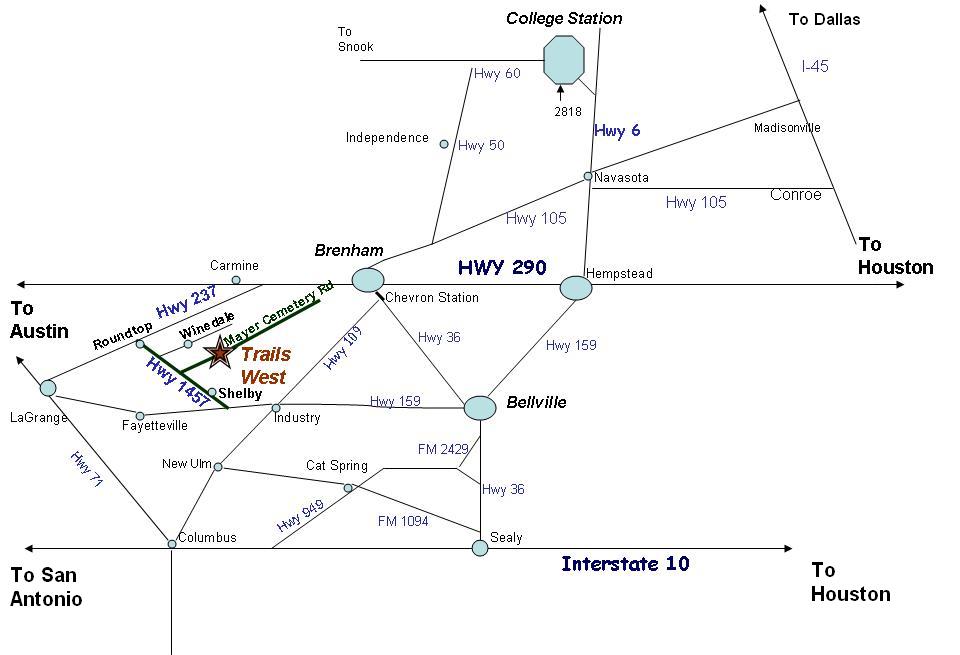
|
Please be aware that it is very dark along these roads
at night. If you are unfamiliar with the area, please print out these directions and make sure you arrive in daylight if at
all possible. We have a 7PM check-in deadline unless you make PRIOR arrangements. We are located
about one mile off Hwy 1457 half way between Shelby and Round Top at 10770 Mayer Cemetery Road just past the Burkhardt cemetery.
This is a gravel road. When you pass the Burkhardt Cemetery sign on the left, make the bend in the road. On the right
side is a white board fence entry. TRAILS WEST RETREAT is across the road on the left.The corner of our property is at
Muske-Ulrich Road and Mayer Cemetery. DIRECTIONS:
From Round Top on Hwy 237.
At the yellow blinking light on square, turn East in Front of Royer's Cafe (FM 1457). You will go straight towards
Henkel Square Village. Take a left on Hwy 1457 toward Shelby. Go a little over 4 miles. Take a left on Mayer Cemetery Rd (gravel).
Go 1 mile, pass Burkhardt Cemetery. Immediately around the curve you will see our entrance. It is across from a white board
entry.
From San Antonio on I 10 take Hwy 77 through La Grange to a right on Hwy 71
Loop. Exit Fm 237/Hwy 159, go left under Loop and head N to Round Top. Turn right on the square at the light, left
onto FM 1457 and follow above directions.
From Houston area take Interstate 10 to
Sealy. Take the Hwy 36 exit and go N to Bellville. Go thru Bellville to the Shell station and take HWY 159 W through Industry
(15 miles). 3 miles west of Industry, take a right on Hwy 1457 that runs thru Shelby. Go 3 1/2 miles past Shelby and
turn right on Mayer Cemetery Rd.
From Brenham & Houston 290 area: Travel on 290
loop. Go past Hwy 36 intersection. Take FM 389 (Blinn College exit right off Loop 290). Turn left on 389 and head southwest.
Go 13 miles to Shelby. Turn right on FM 1457 and go 3 miles to Mayer Cemetery Rd. Turn right, go 1.3 miles. (Scenic
Route...5 miles closer, 3 miles gravel road...go 10 miles on FM 389, cross intersection of FM2502 and turn right on BRANDT
RD, go 2 miles, turn RT on LATIUM CEMETERY, go 1/2 mile and turn left, go another mile and turn left on ECKERMANN RD.
Go 1 1/2 miles to a left on Mayer Cemetery. Go 1/4 mile to Muske Ullrich. Our property starts on the right from
there past the little creek. Entry will be on the right.
From Dallas/Ft Worth: Take I 35 through
Waco. Exit right to Loop 340 on south side of Waco. Go under 340 & circle to the right. Go right (north)
on 340. Go 1. 5 miles to a right on US 77. In Giddings, turn left on Hwy 290. Go approx. 15 miles to Carmine. Turn right on Spur
458. Go 3 miles to FM 237. Turn right, go past Big Red Barn just a little way
to a left at the first paved road ALTHAUS RD. Go about
1 mile until it Ts into Havemann RD. Turn left. Go about
1 mile to a RIGHT on KLATT RD. Go 2 miles until it Ts
into WINEDALE RD. Go 1/4 mile to MUSKE-ULLRICH RD. Turn left. This is across from a beautiful horse ranch with white
board fence. Go all the way to the end of Muske-Ullrich. A little over 1 mile. Our entry is right BEFORE
MU Ts into Mayer Cemetery. There is a marked entry on Muske-Ullrich. Look for a rustic wood cedar fence on the right.
Our LODGE/OFFICE is located at the last entry off MU RD. Our Cabins/Cottage is located at 10900 Mayer Cemetery Rd.
Take a right at the intersection off MU to go to the cabins. An
alternate route is to take ROUND TOP Road after you pass Ledbetter from US 290. It
will take you all the way to FM 237 in Round Top. Turn right at the intersection. Go 2 blocks to the RT square.
Turn Right at the yellow blinking light onto FM 1457. Go 3 miles to a right on Winedale Rd. Go 1.5 miles to Muske
Ulrich Rd. Take a right. Go 1.2 miles to a right into the Eagle's Nest Lodge Entry. Or you make go 4.5 miles on
FM 1457 to a left on Mayer Cemetery Rd and go 1 mile. You will see a sign that says Burkhardt Cemetery. We are
right around the bend on the left. We have a lighted entry. TRAILS WEST RETREAT/ EAGLE'S NEST LODGE
is the last place on Muske-Ullrich on the right before it Ts into Mayer Cemetery. Turn right, cross the creek and
the Retreat entrance is on the right. The Lodge is white Austin Stone...the last building on Muske-Ullrich Rd on the
right. From
College Station area: Hwy 60 to a left on Hwy 36. Go past Somerville and take 390
to Burton. Go right on Hwy 290 heading W from Burton, go 1 mile to a left on FM 2502. Go about 2
miles to a right on Fuchs Rd. Go 2 miles. Turn right on Wickel Road at the T and immediately back left on Winedale
Rd. Go about 2 miles. Take a left on Muske-Ullrich Rd and go a little over a mile. When you get to Mayer
Cemtery, you have come to the corner of Trails West. Our lodge is on the right at the corner.
Now if you are still unsure www.mapquest.com or google maps are really
good!
|
|
Trails West Retreat
10770 Mayer Cemetery Road
Burton, Washington County, Texas
77835
Your Hosts:
Betty & Del Meischen
979-278-3409
Del's cell 979-877-4852
Betty's cell
979-885-8912
Print out this map and don't hesitate to call if you still can't find us! There is another more detailed
map by clicking at the bottom of this page. You're never lost--just
temporarily disoriented!
|
|